Running environment :windows10、pycharm、python3.7、gdal etc.
python Use GDAL The following warning appears when cropping remote sensing images :
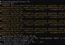
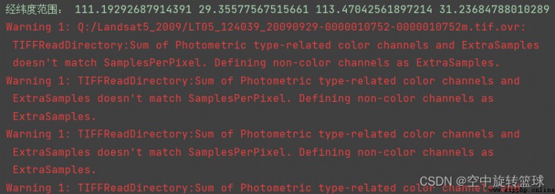
“Warning 1: TIFFReadDirectory:Sum of Photometric type-related color channels and ExtraSamples doesn't match SamplesPerPixel. Defining non-color channels as ExtraSamples.”
Code snippet used :
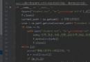
out_ds = gdal.Warp(output_image,#output file full path
ds,#input file 2 ds
format='GTiff',
outputBounds=(x_left, x_bottom, x_right, x_top),
dstNodata=0)
Warp Function has many parameter options :https://gdal.org/python/ https://gdal.org/python/
Warp(destNameOrDestDS, srcDSOrSrcDSTab, **kwargs)
Warp one or several datasets.
Arguments are :
destNameOrDestDS --- Output dataset name or object
srcDSOrSrcDSTab --- an array of Dataset objects or filenames, or a Dataset object or a filename
Keyword arguments are :
options --- return of gdal.WarpOptions(), string or array of strings
other keywords arguments of gdal.WarpOptions()
If options is provided as a gdal.WarpOptions() object, other keywords are ignored.
WarpOptions(options=None, format=None, outputBounds=None,
outputBoundsSRS=None, xRes=None, yRes=None, targetAlignedPixels=False,
width=0, height=0, srcSRS=None, dstSRS=None, coordinateOperation=None,
srcAlpha=False, dstAlpha=False, warpOptions=None, errorThreshold=None,
warpMemoryLimit=None, creationOptions=None, outputType=gdalconst.GDT_Unknown,
workingType=gdalconst.GDT_Unknown, resampleAlg=None, srcNodata=None, dstNodata=None,
multithread=False, tps=False, rpc=False, geoloc=False, polynomialOrder=None,
transformerOptions=None, cutlineDSName=None, cutlineLayer=None, cutlineWhere=None,
cutlineSQL=None, cutlineBlend=None, cropToCutline=False, copyMetadata=True,
metadataConflictValue=None, setColorInterpretation=False, overviewLevel='AUTO',
callback=None, callback_data=None)Parameters to describe :
Create a WarpOptions() object that can be passed to gdal.Warp()
Keyword arguments are :
options --- can be be an array of strings, a string or let empty and filled from other keywords.
format --- output format ("GTiff", etc...)
outputBounds --- output bounds as (minX, minY, maxX, maxY) in target SRS
outputBoundsSRS --- SRS in which output bounds are expressed, in the case they are not expressed in dstSRS
xRes, yRes --- output resolution in target SRS
targetAlignedPixels --- whether to force output bounds to be multiple of output resolution
width --- width of the output raster in pixel
height --- height of the output raster in pixel
srcSRS --- source SRS
dstSRS --- output SRS
coordinateOperation -- coordinate operation as a PROJ string or WKT string
srcAlpha --- whether to force the last band of the input dataset to be considered as an alpha band
dstAlpha --- whether to force the creation of an output alpha band
outputType --- output type (gdalconst.GDT_Byte, etc...)
workingType --- working type (gdalconst.GDT_Byte, etc...)
warpOptions --- list of warping options
errorThreshold --- error threshold for approximation transformer (in pixels)
warpMemoryLimit --- size of working buffer in MB
resampleAlg --- resampling mode
creationOptions --- list of creation options
srcNodata --- source nodata value(s)
dstNodata --- output nodata value(s)
multithread --- whether to multithread computation and I/O operations
tps --- whether to use Thin Plate Spline GCP transformer
rpc --- whether to use RPC transformer
geoloc --- whether to use GeoLocation array transformer
polynomialOrder --- order of polynomial GCP interpolation
transformerOptions --- list of transformer options
cutlineDSName --- cutline dataset name
cutlineLayer --- cutline layer name
cutlineWhere --- cutline WHERE clause
cutlineSQL --- cutline SQL statement
cutlineBlend --- cutline blend distance in pixels
cropToCutline --- whether to use cutline extent for output bounds
copyMetadata --- whether to copy source metadata
metadataConflictValue --- metadata data conflict value
setColorInterpretation --- whether to force color interpretation of input bands to output bands
overviewLevel --- To specify which overview level of source files must be used
callback --- callback method
callback_data --- user data for callback
This error occurs before cropping the image , However, the calculated results , There is no big problem to open the calculation result view .
The data used are 19 Band , One after another 17 OK, this warning .
Because from 4 individual CMYK Channel transfer to 3 individual RGB passageway , That's why our image color changes .
As you can see on Google :“RGB It refers to the three primary colors of light , red 、 Green and blue , For display 、 TV screen 、 Digital cameras and scanners .CMYK It refers to the primary color of the pigment : Cyan 、 magenta 、 yellow 、 black . ... When from RGB The switch to CMYK when , We may notice the change of color .”
The warning means that each pixel of the image has 4 Samples , but Protometric TIFF The label is set to RGB, No, ExtraSamples Label settings .GDAL Gave a warning , because 3 + 0 It's not equal to 4. Then it sets a band to ExtraSample, Now? 3 + 1 be equal to 4, Everything is OK Of , At least technically .
It means creating TIFF The author of the file wrote metadata incorrectly . Maybe the metadata tells the image that there are no additional samples ( Band ) Of RGB type , But actually the image has four bands ,GDAL Treat it as RGBA. By doing so ,GDAL At least one band will not be discarded , But it may make wrong guesses about the role of additional bands , It doesn't have to be alpha But it may also contain data ( for example RGB+Near Infrared).
I add a line of code :
options=["TILED=YES", "COMPRESS=LZW"],# Image compression mode selection This error was not reported , However, the image is not compressed when it is opened for viewing , Didn't work .
……
I am also exploring other ways , Maybe setting a parameter option can solve , Welcome big guys to leave messages and exchange !
 [leetcode question brushing Python] 452 Detonate the balloon with the minimum number of arrows
1 subject There are many sphe
 It is recommended to share 8 super easy-to-use Python automation scripts
You may perform many repetitiv